Representation of Geographical Features — Concept Maps
ICSE · Class 7 · Geography
4 concept maps of Representation of Geographical Features for ICSE Class 7 Geography, each also written out as a text outline.
Interactive on Super Tutor
Studying Representation of Geographical Features? Get the full interactive chapter.
Quizzes, flashcards, AI doubt-solver and a step-by-step study plan — built for concept maps and more.
Free trial, no card needed.
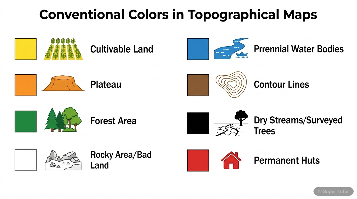
One of 5 illustrations for Representation of Geographical Features in Super Tutor — alongside flashcards, concept maps and practice questions.
Mind map showing the various uses and applications of topographical maps across different sectors and purposes.
The map in words
- Uses of Topographical Maps
- Travel
- Navigation
- Route planning
- Military
- Strategy
- Operations
- Planning
- Urban development
- Infrastructure
- Research
- Geology
- Geography
- Management
- Water resources
- Agriculture
- Travel
Pie chart showing the distribution of different colors and their corresponding features on topographical maps.
The map in words
- Blue: Water: 15
- Green: Forests: 20
- Yellow: Agriculture: 30
- Brown: Relief: 25
- Red: Settlements: 10
Flowchart showing step-by-step process of reading and using grid references to locate features on a topographical map.
The map in words
- Start: Read Grid Reference
- Identify Southwest Corner as Origin
- Find Easting Number Count from West to East
- Find Northing Number Count from South to North
- Locate Intersection Point This is Your Location
- Feature Found Example: Town at 3786
- Locate Intersection Point This is Your Location
- Find Northing Number Count from South to North
- Find Easting Number Count from West to East
- Identify Southwest Corner as Origin
Topographical maps represent natural and man-made features using colours, grid references, scale, and conventional symbols
The map in words
- Topographical maps represent natural and man-made features using colours, grid references, scale, and conventional symbols
- Topographical survey maps
- Survey of India
- Colours on topographical sheets
- Grid reference
- Scale
- Measuring distance
- Conventional signs and symbols
- Drainage and water features
Explore these maps interactively
Explore DiagramsFrequently Asked Questions
What are the important topics in Representation of Geographical Features for ICSE Class 7 Geography?
What do the concept maps for Representation of Geographical Features show?
How should I revise Representation of Geographical Features for Class 7 exams?
Sources & Official References
Content is aligned to the official syllabus. Refer to the board website for the latest curriculum.
More resources for Representation of Geographical Features
Practice Quiz
Test yourself with a quick quiz
Important Questions
Exam-style questions with answers
Revision Notes
Key points for last-minute revision
Formula Sheet
The chapter's formulas in one place
Chapter Summary
Understand the chapter at a glance
Study Plan
Step-by-step plan for this chapter
Flashcards
Quick-fire cards for active recall
Syllabus
What topics to cover
For serious students
Get the full Representation of Geographical Features chapter — start free.
Quizzes, flashcards, an AI doubt solver and a study plan for ICSE Class 7 Geography. Free to start, no card needed.