Representation of Geographical Features — Revision Notes
ICSE · Class 7 · Geography
Representation of Geographical Features revision notes for ICSE Class 7 Geography: 4 topics in quick points. Part of the ICSE Class 7 Geography syllabus.
Interactive on Super Tutor
Studying Representation of Geographical Features? Get the full interactive chapter.
Quizzes, flashcards, AI doubt-solver and a step-by-step study plan — built for revision notes and more.
Free trial, no card needed.
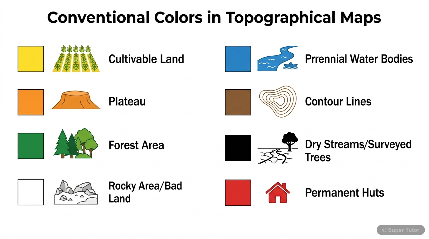
One of 5 illustrations for Representation of Geographical Features in Super Tutor — alongside flashcards, concept maps and practice questions.
Key Topics to Revise
1. Topographical Survey Maps
- Topographical maps show both natural and man-made features of an area.
- Examples of man-made features include highways, huts, cart tracks, hospitals, post offices, perennial lined wells, canals, dams, police stations, and dispensaries.
- Examples of natural features include ridges, conical hills, dry tanks, streams, dry rivers with water channels, and broken ground.
2. Colours Used on Topographical Sheets
- Blue represents waterbody, perennial lined wells, perennial streams, lakes, ponds, and water bodies in general.
- Red represents settlements, permanent huts, and cities.
- Yellow represents cultivable land, plateaus, deserts, and plains.
3. Grid Reference
- Grid references help locate a feature on a topographical map.
- The grid is made of vertical and horizontal lines.
- Vertical lines are called eastings.
4. Scale and Its Types
- Scale shows the relation between distance on the map and actual distance on the land.
- Scale can be written as a ratio between map distance and ground distance using the same unit.
- Large scale maps show a small area in greater detail.
Get complete notes with diagrams and examples
Full NotesKey Concepts
Frequently Asked Questions
What are the important topics in Representation of Geographical Features for ICSE Class 7 Geography?
How should I revise Representation of Geographical Features for Class 7 exams?
Sources & Official References
Content is aligned to the official syllabus. Refer to the board website for the latest curriculum.
More resources for Representation of Geographical Features
Practice Quiz
Test yourself with a quick quiz
Important Questions
Exam-style questions with answers
Formula Sheet
The chapter's formulas in one place
Chapter Summary
Understand the chapter at a glance
Concept Maps
See how topics connect
Study Plan
Step-by-step plan for this chapter
Flashcards
Quick-fire cards for active recall
Syllabus
What topics to cover
For serious students
Get the full Representation of Geographical Features chapter — start free.
Quizzes, flashcards, an AI doubt solver and a study plan for ICSE Class 7 Geography. Free to start, no card needed.