Locational Settings of India
ICSE · Class 12 · Geography
Most important questions from Locational Settings of India for ICSE Class 12 Geography board exam 2026. MCQs, short answer, and long answer questions with marks.
Interactive on Super Tutor
Studying Locational Settings of India? Get the full interactive chapter.
Quizzes, flashcards, AI doubt-solver and a step-by-step study plan — built for important questions and more.
1,000+ Class 12 students started this chapter today
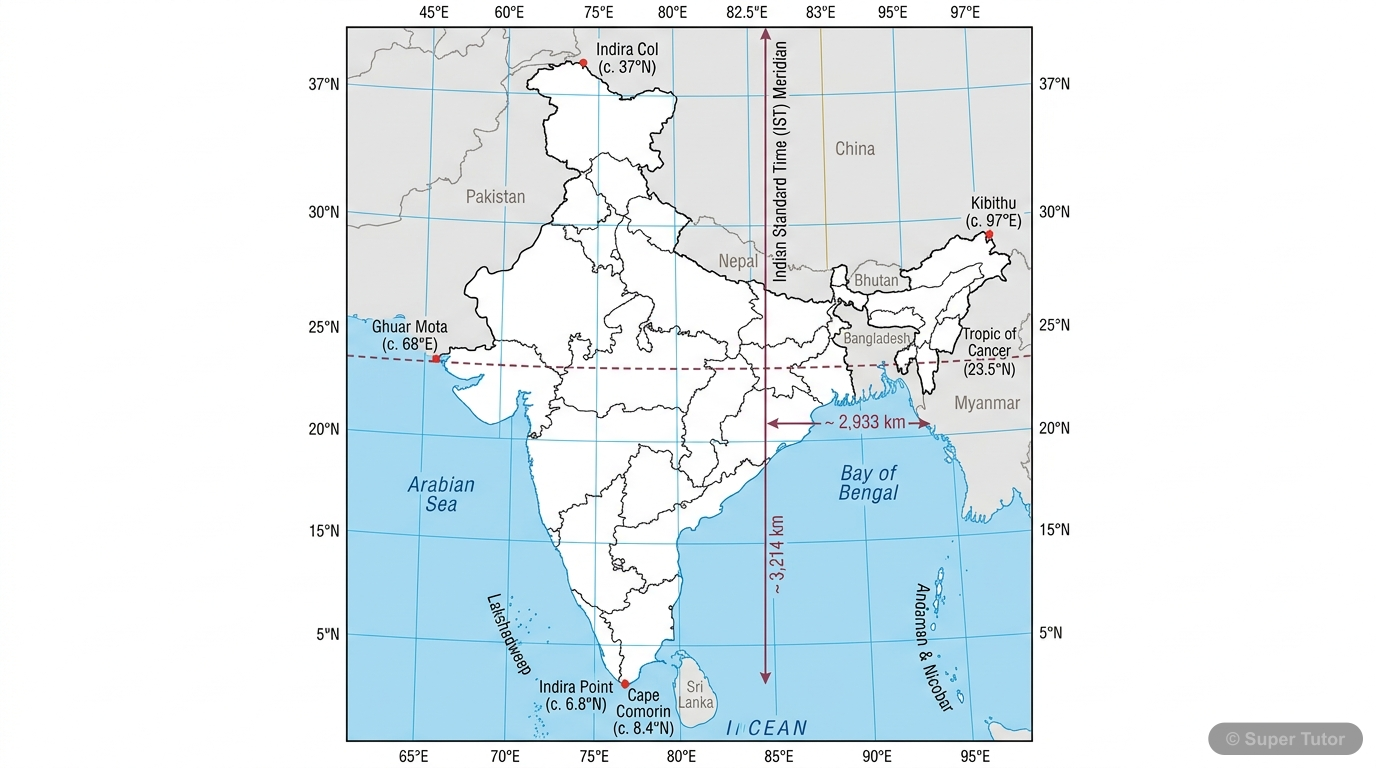
This is just one of 5+ visuals inside Super Tutor's Locational Settings of India chapter
Explore the full setSample Questions
The Tropic of Cancer passes through the middle of India. Which of the following best explains its significance for India's climate?
Show answer
It divides India into tropical south and subtropical north, giving diverse climate
Step 1: The Tropic of Cancer (23.5°N) passes through the middle of India. Step 2: Areas south of the Tropic of Cancer (like Kerala, Tamil Nadu) experience a tropical climate with high temperatures and heavy rainfall. Step 3: Areas north of the Tropic of Cancer (like Delhi, Punjab) experience a subtropical climate with extreme temperature variations. Step 4: This division creates India's remarkable climatic diversity — from near-equatorial conditions in the south to cold, dry conditions in the north during winter. Step 5: Option A is incorrect because the northern part has a subtropical climate
What is the total length of the coastline of India including the islands?
Show answer
7,517 km
Step 1: India has two types of sea frontiers — mainland coastline and island coastlines. Step 2: The mainland coastline is approximately 6,100 km long. Step 3: When the coastlines of Andaman and Nicobar Islands and Lakshadweep Islands are added to this, the total sea frontier extends to 7,517 km. Step 4: Option A (6,100 km) is incorrect because it only counts the mainland coastline. Step 5: The total coastline of 7,517 km makes India one of the countries with the longest coastlines in Asia, enhancing its maritime importance.
Where is Indira Point located and what is its significance?
Show answer
It is in Andaman and Nicobar Islands and is India's southernmost point at 6°45'N
Step 1: Indira Point is the southernmost tip of India's entire territory. Step 2: It is located in the Andaman and Nicobar Islands at 6°45' North latitude. Step 3: It is important to distinguish this from the mainland's southernmost point (8°4'N at Kanniyakumari). Step 4: Indira Point brings India very close to the equator and is strategically located in the eastern Indian Ocean. Step 5: Options A, C, and D are all wrong — Lakshadweep is in the Arabian Sea (west), Indira Col is in Kashmir (northernmost), and Arunachal Pradesh is in the east.
The Indian Ocean has been named after India. Which of the following statements best explains the reason for this?
Show answer
India's central position and great prominence in early oceanic trade gave it this distinction
Step 1: The Indian Ocean is the only ocean named after a country. Step 2: This is because India occupied a position of great prominence in ancient times when these oceans were being named. Step 3: India's central location at the head of the Indian Ocean made it the principal hub of trade routes connecting the East and the West. Step 4: India was so dominant in oceanic trade that it earned the title 'Mistress of the Eastern Seas'. Step 5: Option A is incorrect — Australia also borders the Indian Ocean and is large. The naming is about historical prominence and centrality, not just physical size
+40 more questions available
Practice AllFrequently Asked Questions
What are the important topics in Locational Settings of India for ICSE Class 12 Geography?
How to score full marks in Locational Settings of India — ICSE Class 12 Geography?
How many important questions are there in Locational Settings of India?
Sources & Official References
Content is aligned to the official syllabus. Refer to the board website for the latest curriculum.
More resources for Locational Settings of India
Practice Quiz
Test yourself with a quick quiz
Revision Notes
Key points for last-minute revision
Formula Sheet
All formulas in one place
Chapter Summary
Understand the chapter at a glance
Concept Maps
See how topics connect visually
Study Plan
Step-by-step plan to ace this chapter
Flashcards
Quick-fire cards for active recall
Syllabus
What topics to cover
NCERT Solutions
Every textbook question solved step by step
For serious students
Get the full Locational Settings of India chapter — for free.
Quizzes, flashcards, AI doubt-solver and a step-by-step study plan for ICSE Class 12 Geography.