Locational Settings of India — Flashcards
ICSE · Class 12 · Geography
30 flashcards for Locational Settings of India (ICSE Class 12 Geography) to test yourself on key terms and facts.
Interactive on Super Tutor
Studying Locational Settings of India? Get the full interactive chapter.
Quizzes, flashcards, AI doubt-solver and a step-by-step study plan — built for flashcards and more.
Free trial, no card needed.
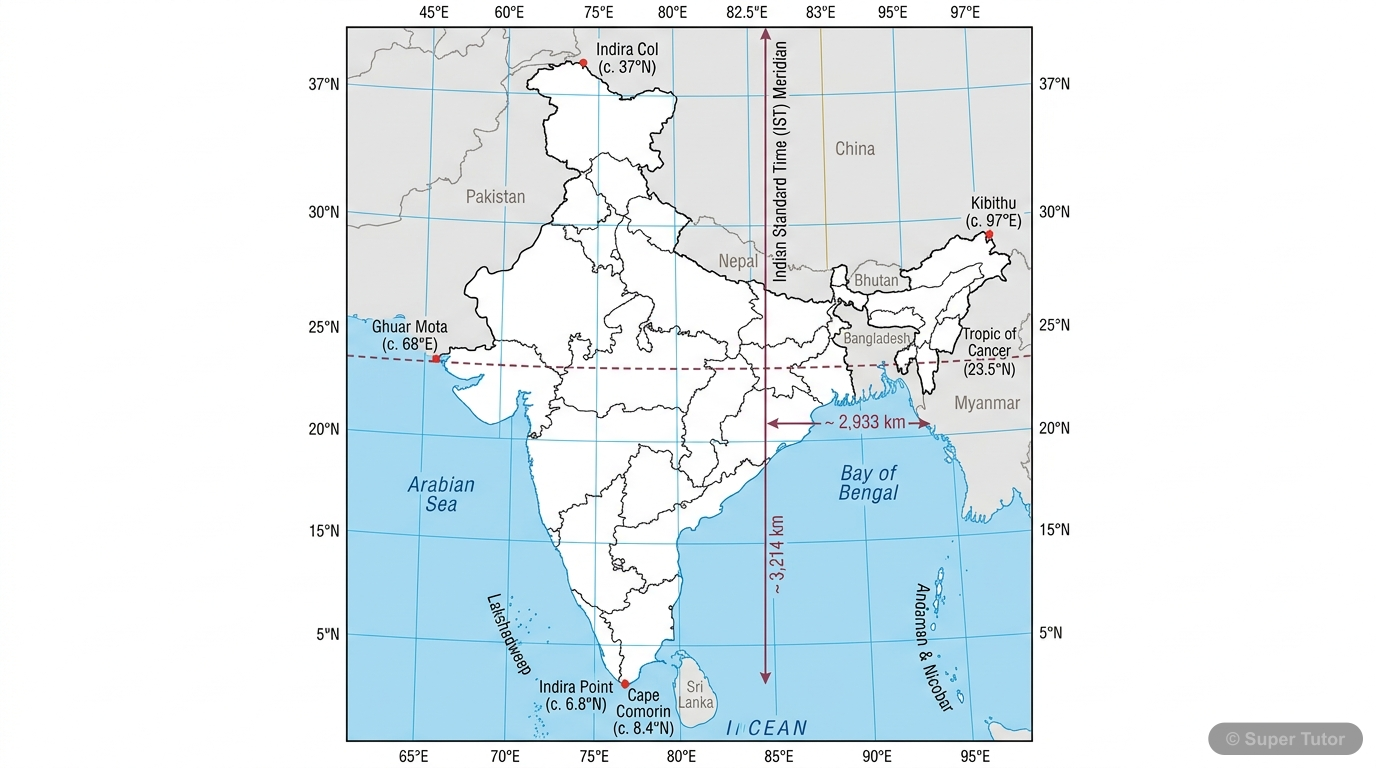
Learn better with visuals Super Tutor pairs illustrations like this with notes and quizzes for Locational Settings of India.
What is meant by India being a subcontinent?
Answer
India is called a subcontinent because it is a vast landmass with major physical and cultural diversity. It includes the Himalayas, the Great Indo-Gangetic Plain, the Thar Desert, and Peninsular India…
Why is the Himalayas an important northern boundary of India?
Answer
The Himalayas form the lofty mountain range in the north of India. They are partly permanently ice-covered and separate India from the rest of Asia. They also help define India’s physical setting and …
What is the Great Indo-Gangetic Plain?
Answer
The Great Indo-Gangetic Plain is the fertile plain south of the Himalayas. It is known for its rich soil and is one of the most important agricultural regions of India.
What is the Thar Desert in India’s physical setting?
Answer
The Thar Desert is the western part of the Indo-Gangetic Plain area mentioned in the chapter context. It represents the dry western region of this vast land system.
What is Peninsular India?
Answer
Peninsular India is the uneven plateau region south of the Indo-Gangetic Plain. It is surrounded by the Eastern Coastal Plain on the east and the Western Coastal Plain on the west.
What are India’s latitudinal and longitudinal limits?
Answer
India extends from 8° 4′ north to 37° 6′ north latitude and from 68° 7′ east to 97° 25′ east longitude. Its latitudinal and longitudinal extent is about thirty degrees each.
How much is India’s latitudinal extent compared with the distance from the Equator to the North Pole?
Answer
India’s latitudinal extent is about one-third the angular distance between the Equator and the North Pole. This shows that India stretches far from south to north.
How much is India’s longitudinal extent compared with the circumference of the Equator?
Answer
India’s longitudinal extent is about one-twelfth of the circumference of the Equator. This explains why there is a time difference between the eastern and western parts of the country.
+22 more flashcards
Practise AllFrequently Asked Questions
What are the important topics in Locational Settings of India for ICSE Class 12 Geography?
How many flashcards are available for Locational Settings of India?
How should I revise Locational Settings of India for the ICSE Class 12 board exam?
Sources & Official References
Content is aligned to the official syllabus. Refer to the board website for the latest curriculum.
More resources for Locational Settings of India
Practice Quiz
Test yourself with a quick quiz
Important Questions
Exam-style questions with answers
Revision Notes
Key points for last-minute revision
Formula Sheet
The chapter's formulas in one place
Chapter Summary
Understand the chapter at a glance
Concept Maps
See how topics connect
Study Plan
Step-by-step plan for this chapter
Syllabus
What topics to cover
For serious students
Get the full Locational Settings of India chapter — start free.
Quizzes, flashcards, an AI doubt solver and a study plan for ICSE Class 12 Geography. Free to start, no card needed.