Representation of Geographical Features
ICSE · Class 7 · Geography
Most important questions from Representation of Geographical Features for ICSE Class 7 Geography board exam 2026. MCQs, short answer, and long answer questions with marks.
Interactive on Super Tutor
Studying Representation of Geographical Features? Get the full interactive chapter.
Quizzes, flashcards, AI doubt-solver and a step-by-step study plan — built for important questions and more.
1,000+ Class 7 students started this chapter today
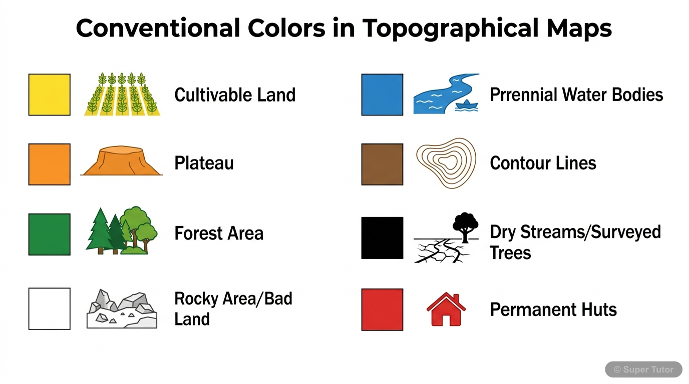
This is just one of 5+ visuals inside Super Tutor's Representation of Geographical Features chapter
Explore the full setSample Questions
On a topographical survey map with scale 2 cm = 1 km, a linear scale is provided. To the left of zero, the 2 cm compartment is divided into 10 equal parts. What distance does each small part on the left side represent?
Show answer
100 metres
Step 1: The scale is 2 cm = 1 km. So the left compartment (2 cm) represents 1 km = 1,000 metres. Step 2: This 2 cm compartment on the left of zero is divided into 10 equal parts. Step 3: Each small part = 1,000 metres ÷ 10 = 100 metres. Step 4: The left side of a linear scale is always subdivided for more precise, smaller measurements. Step 5: 10 metres would require 100 subdivisions; 50 metres would require 20; 200 metres would be only 5 divisions. So 100 metres per small division is correct.
On toposheet No. G43S7, the four-figure grid reference of a temple is 4285. Which of the following correctly identifies the easting and northing values?
Show answer
Easting 42, Northing 85
Step 1: A four-figure grid reference combines two two-digit numbers — the first two digits are the easting and the last two digits are the northing. Step 2: Grid reference 4285 → Easting = 42, Northing = 85. Step 3: The rule is: Eastings always come first (read along the bottom from west to east), then Northings (read up from south to north). Step 4: The origin is always the South-West corner of the map. Step 5: Option A reverses easting and northing. Options C and D split the numbers incorrectly. Always remember: 'Read right first (easting), then up (northing).'
A surveyor marks a point on a rock wall with the notation 'BM 63.3'. What does this marking tell us about that specific location?
Show answer
It is a bench mark showing that point is 63.3 metres above mean sea level
Step 1: BM stands for Bench Mark — a surveyor's mark cut on a rock, stone, wall, or building. Step 2: The number (63.3) shows the exact height of that mark above mean sea level (MSL). Step 3: Bench marks are permanent reference points used in surveying to establish height for other points. Step 4: A spot height (shown as •340) gives the height of a point above sea level but is not a physically cut mark. Step 5: Triangulated height uses a small triangle symbol (△). Bench marks are the most precise, physically verified height markers on a toposheet.
On a topographical map, an area is shown in white colour. What does this white colour most accurately indicate?
Show answer
Rocky, stony, or badland area that is uncultivable
Step 1: Each colour on a toposheet has a universally accepted meaning for map reading. Step 2: White on a topographical map represents rocky areas, badlands, stony waste, or areas covered with sheet rock — all of which are uncultivable. Step 3: Yellow represents cultivable land (agriculture, plateaus, plains). Blue represents water bodies. Red represents settlements. Step 4: Snow-covered glaciers are not a standard colour code in Indian toposheets — white specifically means barren/rocky uncultivable land. Step 5: Seasonal water bodies are shown in black speckles (dry tank) or light blue. White
+40 more questions available
Practice AllFrequently Asked Questions
What are the important topics in Representation of Geographical Features for ICSE Class 7 Geography?
How to score full marks in Representation of Geographical Features — ICSE Class 7 Geography?
How many important questions are there in Representation of Geographical Features?
Sources & Official References
Content is aligned to the official syllabus. Refer to the board website for the latest curriculum.
More resources for Representation of Geographical Features
Practice Quiz
Test yourself with a quick quiz
Revision Notes
Key points for last-minute revision
Formula Sheet
All formulas in one place
Chapter Summary
Understand the chapter at a glance
Concept Maps
See how topics connect visually
Study Plan
Step-by-step plan to ace this chapter
Flashcards
Quick-fire cards for active recall
Syllabus
What topics to cover
NCERT Solutions
Every textbook question solved step by step
For serious students
Get the full Representation of Geographical Features chapter — for free.
Quizzes, flashcards, AI doubt-solver and a step-by-step study plan for ICSE Class 7 Geography.