Representation of Geographical Features — Concept Maps
ICSE · Class 8 · Geography
4 concept maps of Representation of Geographical Features for ICSE Class 8 Geography, each also written out as a text outline.
Interactive on Super Tutor
Studying Representation of Geographical Features? Get the full interactive chapter.
Quizzes, flashcards, AI doubt-solver and a step-by-step study plan — built for concept maps and more.
Free trial, no card needed.
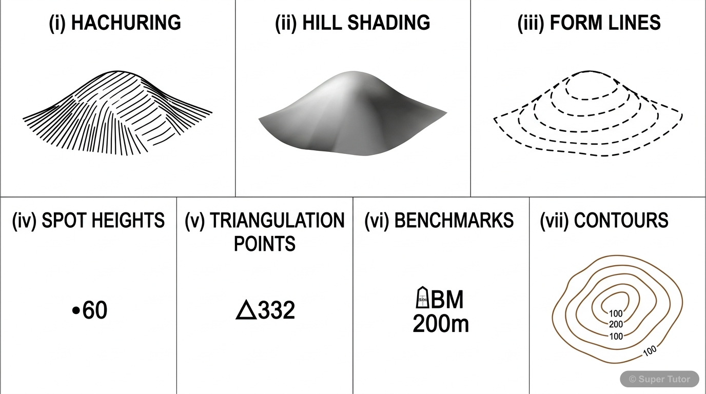
Learn better with visuals Super Tutor pairs illustrations like this with notes and quizzes for Representation of Geographical Features.
Representation of Geographical Features – Complete Overview
The map in words
- Geographical Features
- Methods of Relief
- Hachuring
- Short slope lines
- No actual height
- Hill Shading
- Light and shadow
- No actual height
- Form Lines
- Broken dashed lines
- Approximate heights
- Spot Heights
- Dot with number
- Actual measured height
- Triangulation
- Trigonometry used
- Triangle symbol
- Bench Marks
- Permanent stone marker
- Written as BM
- Hachuring
- Contour Lines
- Equal height line
- Brown colour
- Interval is 20m
- Index Contour every 5th
- Close lines steep slope
- Wide lines gentle slope
- Landforms by Contours
- Conical Hill
- Circular closed loops
- Plateau
- Wide central gap
- Cliff
- Merging contours
- Waterfall
- Merge on river
- Ridge or Escarpment
- Close and wide sides
- Pass and Col
- Gap between hills
- Saddle
- Shallow depression
- Conical Hill
- Settlement Patterns
- Nucleated
- Clustered huts
- Near stations mines
- Linear
- Along road or river
- Trade and transport
- Scattered
- Isolated remote huts
- Unnamed on map
- Nucleated
- Toposheet Colours
- Blue for water
- Yellow for cultivation
- Green for forest
- Red for settlements
- Brown for contours
- White for rocky land
- Methods of Relief
Representation of Geographical Features - Complete Overview
The map in words
- Representation of Geographical Features
- Methods of Relief Representation
- Contours
- Definition
- Index Contours
- Contour Interval
- Historical Methods
- Hachuring
- Hill Shading
- Spot Heights
- Triangulation
- Bench Marks
- Form Lines
- Contours
- Landforms and Contour Patterns
- Conical Hill
- Circular Contours
- Uniform Spacing
- Ridge
- V-shaped Pattern
- Watershed Ridge
- Scarp and Dip Slopes
- Plateau
- Flat Top
- Edge Contours
- Cliff
- Merged Contours
- Vertical Slopes
- Waterfall
- V-shape across River
- Steep Drop
- Pass and Col
- Mountain Routes
- Depression Points
- Conical Hill
- Settlement Patterns
- Nucleated
- Clustered Huts
- Red Color
- Services Present
- Linear
- Along Roads or Rivers
- Trade Development
- Scattered
- Dispersed Huts
- Remote Areas
- Nucleated
- Map Interpretation Skills
- Slope Analysis
- Close Contours
- Distant Contours
- Contour Reading
- Height Calculation
- Pattern Recognition
- Direction Finding
- Compass Rose
- Relative Positions
- Scale Understanding
- 1:50,000 Standard
- Distance Calculation
- Slope Analysis
- Methods of Relief Representation
Representation of Geographical Features - Complete Overview
The map in words
- Representation of Geographical Features
- Methods of Relief Representation
- Hachuring
- Shows slope direction
- Closer lines = steeper
- Hill Shading
- Light and shade effect
- Realistic visualization
- Form Lines
- Broken contour lines
- Approximate heights
- Spot Heights
- Marked with dot
- Absolute heights
- Triangulation
- Marked with triangle
- Mathematical measurement
- Bench Marks
- Permanent survey points
- Reference heights
- Hachuring
- Contours Fundamentals
- Definition
- Lines of equal height
- Imaginary lines
- Properties
- Never intersect
- Brown color
- Show 3D on 2D
- Index Contours
- Every fifth contour
- Bold/accentuated
- Shows major heights
- Definition
- Types of Slopes
- Steep Slope
- Close contours
- Rapid height change
- Gentle Slope
- Wide contours
- Slow height change
- Uniform Slope
- Equal spacing
- Consistent gradient
- Steep Slope
- Landforms by Contours
- Hills and Ridges
- Conical hill
- Mountain ridge
- Watershed ridge
- Plateaus and Cliffs
- Plateau
- Cliff
- Waterfall
- Depressions
- Pass
- Saddle
- Col
- Gap
- Hills and Ridges
- Settlement Patterns
- Nucleated
- Clustered huts
- Community facilities
- Red color
- Linear
- Along river or road
- Trade corridors
- Line arrangement
- Scattered
- Isolated huts
- Remote areas
- Sparse population
- Nucleated
- Map Interpretation
- Contour Analysis
- Relief features
- Slope steepness
- Elevation changes
- Settlement Analysis
- Type identification
- Development level
- Infrastructure
- Directional Analysis
- Map arrow
- Compass directions
- Relative positions
- Contour Analysis
- Methods of Relief Representation
Topographical representation of relief and settlements
The map in words
- Topographical representation of relief and settlements
- Methods of representing relief
- Contours
- Landforms shown by contours
- Types of slopes
- Settlement patterns
- Toposheet G43S7
- Conventional signs and colours
- Survey and map making
Explore these maps interactively
Explore DiagramsFrequently Asked Questions
What are the important topics in Representation of Geographical Features for ICSE Class 8 Geography?
What do the concept maps for Representation of Geographical Features show?
How should I revise Representation of Geographical Features for Class 8 exams?
Sources & Official References
Content is aligned to the official syllabus. Refer to the board website for the latest curriculum.
More resources for Representation of Geographical Features
Practice Quiz
Test yourself with a quick quiz
Important Questions
Exam-style questions with answers
Revision Notes
Key points for last-minute revision
Chapter Summary
Understand the chapter at a glance
Study Plan
Step-by-step plan for this chapter
Flashcards
Quick-fire cards for active recall
Syllabus
What topics to cover
For serious students
Get the full Representation of Geographical Features chapter — start free.
Quizzes, flashcards, an AI doubt solver and a study plan for ICSE Class 8 Geography. Free to start, no card needed.