Relief — Concept Maps
ICSE · Class 12 · Geography
4 concept maps of Relief for ICSE Class 12 Geography, each also written out as a text outline. Part of the ICSE Class 12 Geography syllabus.
Interactive on Super Tutor
Studying Relief? Get the full interactive chapter.
Quizzes, flashcards, AI doubt-solver and a step-by-step study plan — built for concept maps and more.
Free trial, no card needed.
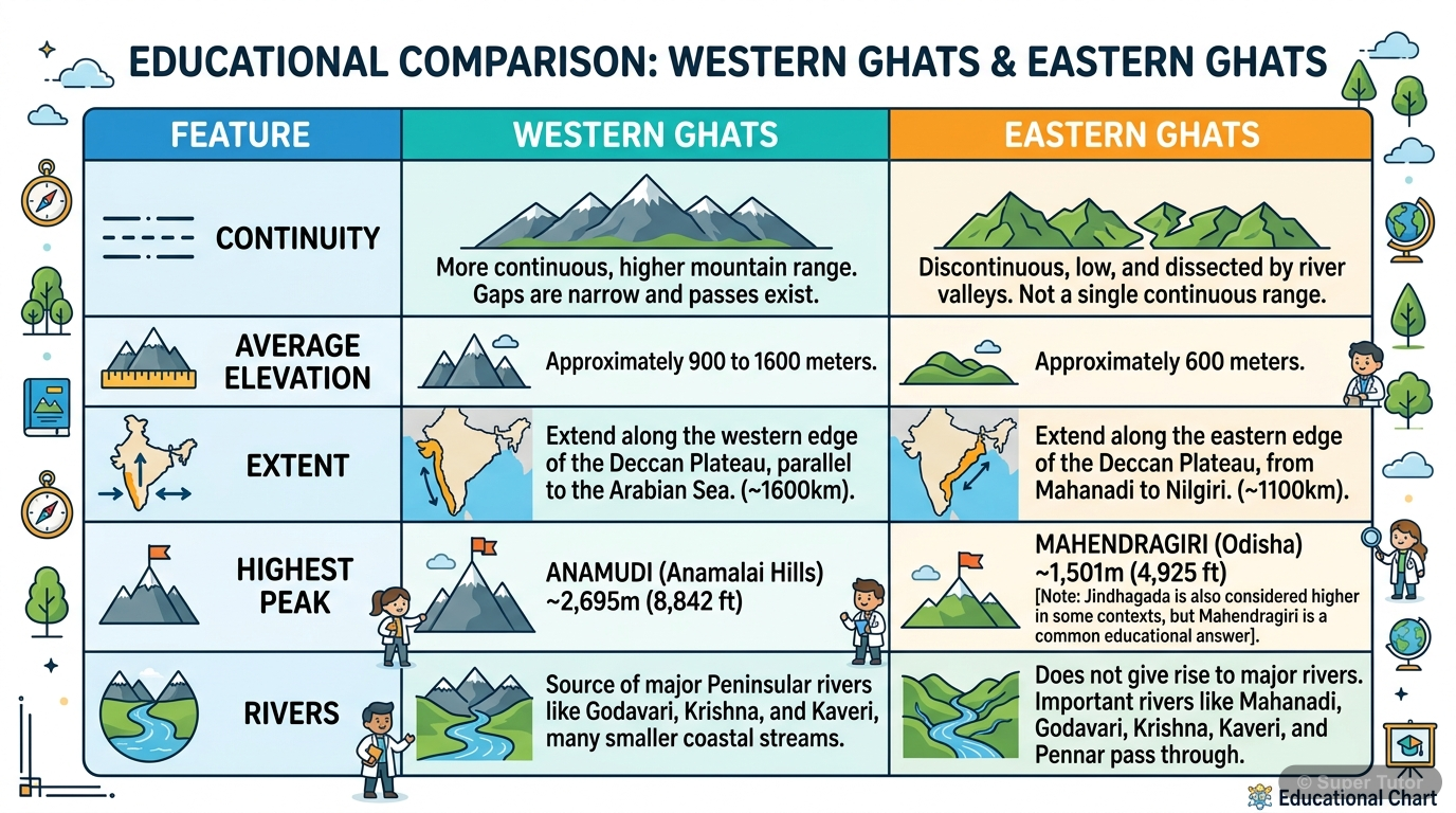
An illustration from Super Tutor's Relief chapter — alongside flashcards, concept maps and practice questions.
Relief of India – Complete Chapter Overview
The map in words
- Relief of India
- Himalayan Mountain Complex
- Three Parallel Ranges
- Great Himalayas Himadri
- Above 6000 m
- Snow covered
- Lesser Himalayas
- 3700-4500 m
- Hill Stations
- Outer Himalayas Shiwalik
- 900-1200 m
- Duns and Duars
- Great Himalayas Himadri
- Regional Divisions
- Kashmir Punjab Himalayas
- Kumaon Himalayas
- Nepal Himalayas
- Assam Himalayas
- Significance
- Climate Control
- River Source
- Defence
- Tourism
- Three Parallel Ranges
- Indus Ganga Brahmaputra Plain
- Relief Features
- Bhabar 8-16 km
- Tarai 20-30 km
- Bhangar Old Alluvium
- Khadar New Alluvium
- Bhur
- Barkhan Desert Dune
- Regional Sub-divisions
- Rajasthan Plain
- Punjab Haryana Plain
- Ganga Plain
- Brahmaputra Plain
- Relief Features
- Peninsular Plateau
- Malwa Plateau
- Aravalis
- Chambal Badlands
- Deccan Plateau
- Western Ghats
- Eastern Ghats
- Slope West to East
- Chhotanagpur Plateau
- Gondwana Coal
- Damodar Valley
- Ranchi Plateau
- Malwa Plateau
- Coastal Plains
- West Coastal Plain
- Konkan
- Kannad
- Malabar
- East Coastal Plain
- North Circar
- Coromandel Plain
- West Coastal Plain
- Islands
- Lakshadweep
- Arabian Sea
- Coral Origin
- 25 Islands
- Andaman and Nicobar
- Bay of Bengal
- 572 Islands
- Volcanic Origin
- Lakshadweep
- Himalayan Mountain Complex
Flowchart showing how all relief divisions interconnect to form India's geographical system
The map in words
- India's Relief System
- Himalayas
- Determines Climate
- Integrated Geographical System
- Provides Rivers
- Creates Resources
- Determines Climate
- Plains
- Supports Agriculture
- Holds Population
- Transport Network
- Plateau
- Contains Minerals
- Supports Forests
- Tourism Potential
- Coasts
- Maritime Trade
- Port Development
- Islands
- Strategic Assets
- Unique Ecosystems
- Himalayas
Relief Features of India: Complete Overview
The map in words
- Relief of India
- Himalayan Mountains
- Great Himalayas
- Highest peaks
- Snow-covered
- Avg 6000m
- Lesser Himalayas
- 3700-4500m
- Hill stations
- Valleys
- Shiwalik Range
- 900-1200m
- Sub-Himalayan
- Significance
- Climate control
- River source
- Defence barrier
- Minerals
- Great Himalayas
- Northern Plain
- Bhabar
- Porous beds
- Underground flow
- Tarai
- Marshy areas
- Re-emergence
- Forests
- Bhangar
- Old alluvium
- Kankar impregnated
- Khadar
- Newer alluvium
- Fertile soil
- Annual flooding
- Regional Divisions
- Rajasthan Plain
- Punjab-Haryana
- Ganga Plain
- Brahmaputra Plain
- Bhabar
- Peninsular Plateau
- Malwa Plateau
- North-west region
- Granite rocks
- Deccan Plateau
- Southern region
- West to East slope
- Chotanagpur Plateau
- North-east region
- Coal deposits
- Border Ranges
- Aravalis
- Western Ghats
- Eastern Ghats
- Malwa Plateau
- Coastal Plains
- West Coast
- Narrow 64km
- Estuaries
- Indented
- East Coast
- Broader 80-100km
- River deltas
- Straight
- West Coast
- Islands
- Andaman-Nicobar
- 572 islands
- Volcanic origin
- 8249 sq km
- Lakshadweep
- 25 islands
- Coral atolls
- Arabian Sea
- Andaman-Nicobar
- Himalayan Mountains
Relief of India
The map in words
- Relief of India
- Himalayan Mountain Complex
- Indus-Ganga-Brahmaputra Plain
- Peninsular Plateau
- Coastal Plains
- Islands
- Relief significance
Explore these maps interactively
Explore DiagramsFrequently Asked Questions
What are the important topics in Relief for ICSE Class 12 Geography?
What do the concept maps for Relief show?
How should I revise Relief for the ICSE Class 12 board exam?
Sources & Official References
Content is aligned to the official syllabus. Refer to the board website for the latest curriculum.
More resources for Relief
Practice Quiz
Test yourself with a quick quiz
Important Questions
Exam-style questions with answers
Revision Notes
Key points for last-minute revision
Chapter Summary
Understand the chapter at a glance
Study Plan
Step-by-step plan for this chapter
Flashcards
Quick-fire cards for active recall
Syllabus
What topics to cover
For serious students
Get the full Relief chapter — start free.
Quizzes, flashcards, an AI doubt solver and a study plan for ICSE Class 12 Geography. Free to start, no card needed.