Relief
ICSE · Class 12 · Geography
Most important questions from Relief for ICSE Class 12 Geography board exam 2026. MCQs, short answer, and long answer questions with marks.
Interactive on Super Tutor
Studying Relief? Get the full interactive chapter.
Quizzes, flashcards, AI doubt-solver and a step-by-step study plan — built for important questions and more.
1,000+ Class 12 students started this chapter today
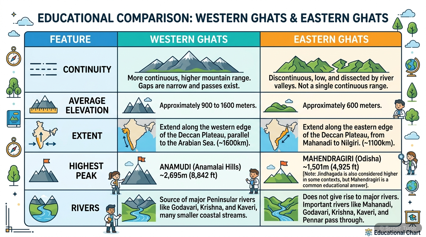
This is just one of 5+ visuals inside Super Tutor's Relief chapter
Explore the full setSample Questions
According to the regional divisions by Sir S. Burrard, the section of the Himalayas between the Kali and the Tista rivers is known as:
Show answer
The Nepal Himalayas
Step 1: Sir S. Burrard divided the Himalayas into four regional sections separated by river gorges. Step 2: The Kashmir/Punjab Himalayas lie between the Indus and the Satluj. Step 3: The Himachal/Uttarakhand/Kumaon Himalayas lie between the Satluj and the Kali. Step 4: The Nepal Himalayas are situated between the Kali and the Tista rivers, extending 800 km and containing the highest peaks like Everest, Kanchenjunga, and Annapurna. Step 5: The Assam Himalayas extend between the Tista and the Dihang (Brahmaputra). So, the section between Kali and Tista is the Nepal Himalayas.
The narrow belt of 8 to 16 km width lying along the foot of the Shiwaliks, composed of pebble-studded porous beds where streams disappear underground, is called:
Show answer
Bhabar
Step 1: The Great Plain of north India has several distinct relief sub-divisions. Step 2: The Bhabar lies along the foot of the Shiwaliks from the Indus to the Tista. Step 3: Its key characteristics are: it is 8-16 km wide, composed of pebble-studded porous beds, and streams disappear underground here due to high porosity. Step 4: The Tarai lies south of the Bhabar where these underground streams re-emerge. Bhangar is old alluvium above flood plains. Khadar is the newer flood plain alluvium. Step 5: The porous nature of the Bhabar makes it unsuitable for agriculture, which distinguishes it fro
Old alluvium found above the level of the flood plains, often containing calcareous concretions called 'kankar', is termed as:
Show answer
Bhangar
Step 1: The Great Plain has two important alluvial terrace formations - Bhangar and Khadar. Step 2: Bhangar is composed of old alluvium and forms the alluvial terrace above the flood plains. It is often impregnated with calcareous concretions called kankar, making it less suitable for cultivation. Step 3: Khadar, in contrast, is the flood plain with newer alluvium deposited almost every year during floods, making it very fertile. Step 4: Bhabar is the pebbled zone near the Shiwaliks, and Bhur is the elevated sandy land along the Ganga in the upper Ganga-Yamuna Doab. Step 5: The presence of 'ka
A crescent-shaped sand dune found in the Rajasthan desert, formed when wind direction remains constant, is called:
Show answer
Barkhan (Barchan)
Step 1: The Rajasthan Plain (Great Indian Desert) has several unique landforms. Step 2: A Barkhan or Barchan is a crescent-shaped sand dune that lies transversely to the wind direction with horns trailing out downwind. Step 3: It is formed when the wind direction remains constant and is typically found in the Barmer-Jaisalmer-Ganganagar region. Step 4: A Barchan normally attains a height of 30-35 metres and its width is usually 10 to 20 times its height. Step 5: Barind is a terrace of older alluvium between the Ganga and Brahmaputra. Bhur is a sandy elevated area along the Ganga banks. Tarai i
+41 more questions available
Practice AllFrequently Asked Questions
What are the important topics in Relief for ICSE Class 12 Geography?
How to score full marks in Relief — ICSE Class 12 Geography?
How many important questions are there in Relief?
Sources & Official References
Content is aligned to the official syllabus. Refer to the board website for the latest curriculum.
More resources for Relief
Practice Quiz
Test yourself with a quick quiz
Revision Notes
Key points for last-minute revision
Formula Sheet
All formulas in one place
Chapter Summary
Understand the chapter at a glance
Concept Maps
See how topics connect visually
Study Plan
Step-by-step plan to ace this chapter
Flashcards
Quick-fire cards for active recall
Syllabus
What topics to cover
NCERT Solutions
Every textbook question solved step by step
For serious students
Get the full Relief chapter — for free.
Quizzes, flashcards, AI doubt-solver and a step-by-step study plan for ICSE Class 12 Geography.